Fornelos Rock art
Points of interest
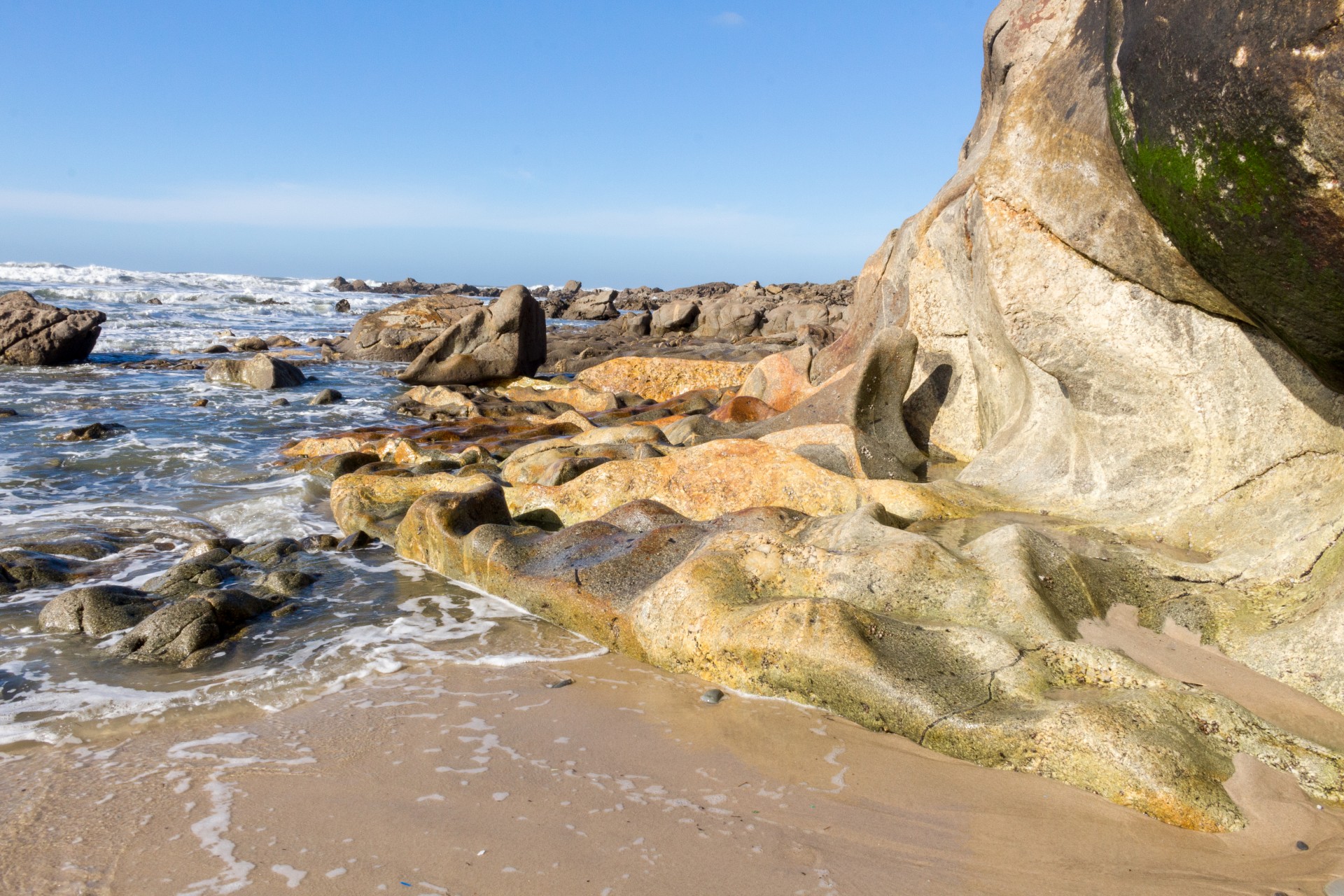
Alcantilado de Montedor (Montedor cliff) geosite – Local National Monument
Classified as a Public National Monument in 2016, the Montedor cliff (alcantilado de Montedor) geosite aggregates several outstanding geomorphological features.
The geological events and geomorphological features that lead to the appearance of the Montedor hill are particularly interesting as they may help us understand how the granite massifs, that are part of the mountain system located closer to the coastline, were formed; the contact metamorphism process which produced the metamorphic rocks surfacing on our beaches, as well as the processes or reactions that lifted these coastal outcrops.
The Montedor cliff, an elevation which interrupts the shoreface , originated from an overflow, to the west towards the sea, of a sheet of magma from the main body of plutonic rock from the Bouça de Frade. This granite mass together with the plutonic rocks of Sta Luzia and Afife form the Viana do Castelo-Caminha massif (Pamplona et al, 2006). The peraluminous magma from which this massif originated emerged from the fusion of the lithosphere crusts of the Laurentia and Gondwana supercontinents which collided between the Devonian and lower Carboniferous period (Paleozoic period), and resulted in the closure of the primitive Rheic Ocean (Nance et al., 2012). The magna generated in the collision migrated between the sediments of the Rheic, metamorphizing (deeper than 5 km) into schist and the schist-geywack complex of the lower Cambrian era and into quartzite and schist of the lower Ordovician era
The combination of the erosion of the rocks of the Rheic, which surrounded the consolidated magma chambers (plutonic), together with the uplifting tectonic process to which the territory was subjected since the end of the Mesozoic era (Alpione orogeny) created the Paleozoic basin on the surface of this territory. The effects of climate warming and of plutonic rocks gaining territory over the rocks of the Rheic, and the geometry of the collision of the Paleozoic supercontinents (oblique and diachronic collision – Variscan deformation phases D1, D2 and D3) may be interpreted in geological terms as of great interest and beauty, due to the resulting thrust faults, folds and paragenesis which may be admired nowadays for example in Montedor.
It is therefore the materials and structures which occurred during the Paleozoic period which dictated the Quaternary geology and geomorphology, by interacting with external geodynamic processes, such as coastal processes or those arising from climatic evolution.
Within this context and on a large-scale analysis, the marine terraces in the exhumed granite allows us to observe the hypsometry position of 5 levels of ancient coastlines (continental shelf) conserved above the present-day shoreline (<1.8m): Platform I (~18m), Platform II (~13m), Platform III (~8m), Platform IV (~4.5-5.5) and Platform V (2-3.5m) (values relative to the average sea level). Some of these terraces still preserve vestiges of biological activity, such as alveolus of sea urchins (ichnofossils, also known as trace fossils) and other indicators of the biological activity on the shoreline, such as concave tide eroded bases or fossilized dune fields.
In other locations where the Viana do Castelo massif distances itself and allows the shoreface to develop, the continental shelf remains hidden under the sandy-muddy sediments which give it a gentle slope into the sea. This landform is also important to allow us to understand how slops evolve in relation to weathering and erosion. This can be observed in the residual geoforms, such as the tafoni or honeycomb, pools, grikes, fluting, pseudostratifcation, stacks or stumps, undulated surfaces and exfoliation.